<Back to Index>
- Tectonic Plate Arabian Plate
- Tectonic Plate Caribbean Plate
- Tectonic Plate Cocos Plate
PAGE SPONSOR
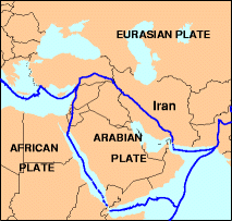
The Arabian Plate is one of three tectonic plates (the African, Arabian and Indian crustal plates) which have been moving northward over millions of years and colliding with the Eurasian Plate. This is resulting in a mingling of plate pieces and mountain ranges extending in the west from the Pyrenees, crossing southern Europe and the Middle East, to the Himalayas and ranges of southeast Asia.
The Arabian Plate consists mostly of the Arabian peninsula; it extends northward to Turkey. The plate borders are:
- East, with the Indo - Australian Plate, at the Owen Fracture Zone.
- South, with the African Plate to the west and the Indo - Australian Plate to the east.
- West, a left lateral fault boundary with the African Plate called the Dead Sea Transform (DST), and a divergent boundary with the African Plate called the Red Sea Rift which runs the length of the Red Sea.
- North, complex convergent boundary with the Anatolian Plate and Eurasian Plate.
The Arabian Plate was part of the African plate during much of the Phanerozoic Eon (Paleozoic - Cenozoic), until the Oligocene Epoch of the Cenozoic Era. Red Sea rifting began in the Eocene, but the separation of Africa and Arabia occurred in the Oligocene, and since then the Arabian Plate has been slowly moving toward the Eurasian Plate.
The collision between the Arabian Plate and Eurasia is pushing up the Zagros Mountains of Iran.
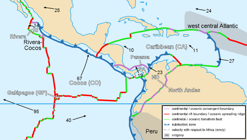
The Caribbean Plate is a mostly oceanic tectonic plate underlying Central America and the Caribbean Sea off the north coast of South America.
Roughly 3.2 million square kilometers (1.2 million square miles) in
area, the Caribbean Plate borders the North American Plate, the South
American Plate, the Nazca Plate and the Cocos Plate. These borders are
regions of intense seismic activity, including frequent earthquakes,
occasional tsunamis and volcanic eruptions.
The northern boundary with the North American plate is a transform or strike - slip boundary which runs from the border area of Belize, Guatemala (Motagua Fault), and Honduras in Central America, eastward through the Cayman trough on south of the southeast coast of Cuba, and just north of Hispaniola, Puerto Rico and the Virgin Islands. Part of the Puerto Rico Trench, the deepest part of the Atlantic Ocean (roughly 8,400 meters), lies along this border. The Puerto Rico trench is at a complex transition from the subduction boundary to the south and the transform boundary to the west.
The eastern boundary is a subduction zone, the Lesser Antilles subduction zone, where oceanic crust of the South American Plate is being subducted under the Caribbean Plate. Subduction forms the volcanic islands of the Lesser Antilles Volcanic Arc from the Virgin Islands in the north to the islands off the coast of Venezuela in the south. This boundary contains seventeen active volcanoes, most notably Soufriere Hills on Montserrat;, Mount Pelée on Martinique; La Grande Soufrière on Guadeloupe; Soufrière Saint Vincent on Saint Vincent; and the submarine volcano Kick-'em-Jenny which lies about 10 km north of Grenada.
Along the geologically complex southern boundary, the Caribbean Plate interacts with the South American Plate forming Barbados, Trinidad and Tobago (all on the Caribbean Plate), and islands off the coast of Venezuela (including the Leeward Antilles) and Colombia. This boundary is in part the result of transform faulting along with thrust faulting and some subduction. The rich Venezuelan petroleum fields possibly result from this complex plate interaction.
The western portion of the plate is occupied by Central America. The
Cocos Plate in the Pacific Ocean
is subducted beneath the Caribbean Plate, just off the western coast of
Central America. This subduction forms the volcanoes of Guatemala, El
Salvador, Nicaragua, and Costa Rica, also known as the Central America
Volcanic Arc.
There are two contending theories as to the origin of the Caribbean Plate.
One holds that it is a large igneous province that formed in the Pacific Ocean tens of millions of years ago. As the Atlantic Ocean widened, North America and South America were pushed westward, separated for a time by oceanic crust. The Pacific Ocean floor subducted under this oceanic crust between the continents. The Caribbean Plate drifted into the same area, but as it was less dense (although thicker) than the surrounding oceanic crust, it did not subduct, but rather overrode the ocean floor, continuing to move eastward relative to North America and South America. With the formation of the Isthmus of Panama 3 million years ago, it ultimately lost its connection to the Pacific.
A more recent theory asserts that the Caribbean Plate came into being
from an Atlantic hotspot which no longer exists. This theory points to
evidence of the absolute motion of the Caribbean Plate which indicates
that it moves westward, not east, and that its apparent eastward motion
is only relative to the motions of the North American Plate and the South American Plate.
The Cocos Plate is an oceanic tectonic plate beneath the Pacific Ocean off the west coast of Central America, named for Cocos Island, which rides upon it.
The Cocos Plate is created by sea floor spreading along the East Pacific Rise and the Cocos Ridge, specifically in a complicated area geologists call the Cocos - Nazca spreading system. From the rise the plate is pushed eastward and pushed or dragged (perhaps both) under the less dense overriding Caribbean Plate, in the process called subduction. The subducted leading edge heats up and adds its water to the mantle above it. In the mantle layer called the asthenosphere, mantle rock melts to make magma, trapping superheated water under great pressure. As a result, to the northeast of the subducting edge lies the continuous arc of volcanos stretching from Costa Rica to Guatemala and a belt of earthquakes that extends farther north, into Mexico.
The northern boundary of the Cocos Plate is the Middle America Trench. The eastern boundary is a transform fault, the Panama Fracture Zone. The southern boundary is a mid-oceanic ridge, the Galapagos Rise. The western boundary is another mid - ocean ridge, the East Pacific Rise.
The Cocos and Nazca Plates are the remnants of the former Farallon Plate, which broke up about 23 million years ago. A hotspot under the Galapagos Islands lies along the Galapagos Rise.
The Rivera Plate north of the Cocos Plate is thought to have separated from the Cocos Plate 5-10 million years ago. The boundary between the two plates appears to lack a definite transform fault, yet they are regarded as distinct.
The devastating 1985 Mexico City earthquake was a result of the subduction of the Cocos Plate beneath the North American Plate. The also devastating 2001 El Salvador earthquakes were generated in the subduction of this plate on the Caribbean Plate