<Back to Index>
- Geologic Period Quaternary, 2.6 Ma
- Geologic Epoch Pleistocene, 2.6 Ma
- Geologic Epoch Holocene, 0.0117 Ma
PAGE SPONSOR
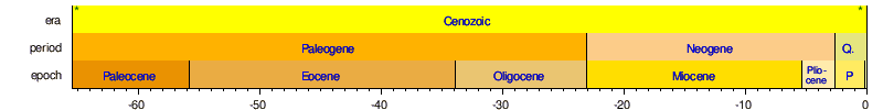
The Quaternary Period is the most recent of the three periods of the Cenozoic Era in the geologic time scale of the ICS. It follows the Neogene Period, spanning 2.588 ± 0.005 million years ago to the present. The relatively short period is characterized by a series of glaciations, the appearance and expansion of anatomically modern humans, and their continuing impact on the natural world. The Quaternary includes two geologic epochs: the Pleistocene and Holocene. A proposed but as of yet informal third epoch, the Anthropocene, has also gained credence as the time in which humans began to profoundly affect and change the global environment, although its start date is still disputed.
The term Quaternary ("fourth") was proposed by Giovanni Arduino in 1759 for alluvial deposits in the Po river valley in northern Italy. It was introduced by Jules Desnoyers in 1829 for sediments of France's Seine Basin that seemed clearly to be younger than Tertiary Period rocks. The Quaternary Period follows the Tertiary Period and extends to the present. The Quaternary covers the time span of glaciations classified as the Pleistocene, and includes the present interglacial period, the Holocene. This places the start of the Quaternary at the onset of Northern Hemisphere glaciation approximately 2.6 million years ago. Prior to 2009, the Pleistocene was defined to be 1.805 million years ago to present, such that the present definition of the Pleistocene includes a portion of what was prior to 2009 defined as part of the Pliocene.
Quaternary stratigraphers usually worked with regional subdivisions. From the 1970s, the International Commission on Stratigraphy (ICS) tried to make a single geologic time scale based on GSSP's, which could be used internationally. The Quaternary subdivisions were defined based on biostratigraphy instead of paleoclimate. This led to the problem that the proposed base of the Pleistocene was at 1.805 Mya, long after the start of the major glaciations of the northern hemisphere. The ICS then proposed to abolish use of the name Quaternary altogether, which appeared unacceptable to the International Union for Quaternary Research (INQUA). In 2009, it was decided to make the Quaternary the youngest period of the Cenozoic Era with its base at 2.588 Mya and including the Gelasian stage, which was formerly considered part of the Neogene Period and Pliocene Epoch.
The 2.6 million years of the Quaternary represents the time during which recognizable humans existed. Over this short time period, there has been relatively little change in the distribution of the continents due to continental drift. The Quaternary geological record is preserved in greater detail than that for earlier periods. The major geographical changes during this time period included the emergence of the Strait of Bosphorus and Skagerrak during glacial epochs, which respectively turned the Black Sea and Baltic Sea into fresh water, followed by their flooding (and return to salt water) by rising sea level; the periodic filling of the English Channel, forming a land bridge between Britain and the European mainland; the periodic closing of the Bering Strait, forming the land bridge between Asia and North America; and the periodic flash flooding of Scablands of the American Northwest by glacial water. The current extent of Hudson Bay, the Great Lakes and other major lakes of North America are a consequence of the Canadian Shield's readjustment since the last ice age; different shorelines have existed over the course of Quaternary time.
The climate was one of periodic glaciations with continental glaciers moving as far from the poles as 40 degrees latitude. There was a major extinction of large mammals in Northern areas at the end of the Pleistocene Epoch. Many forms such as saber - toothed cats, mammoths, mastodons, glyptodonts, etc., became extinct worldwide. Others, including horses, camels and American cheetahs became extinct in North America.
Glaciation took place repeatedly during the Quaternary Ice Age – a term coined by Schimper in 1839 that began with the start of the Quaternary about 2.58 Mya and continues to the present day.
In 1821, a Swiss engineer, Ignaz Venetz, presented an article in which he suggested the presence of traces of the passage of a glacier at a considerable distance from the Alps. This idea was initially disputed by another Swiss scientist, Louis Agassiz, but when he undertook to disprove it, he ended up affirming his colleague's hypothesis. A year later, Agassiz raised the hypothesis of a great glacial period that would have had long reaching general effects. This idea gained him international fame and led to the establishment of the Glacial Theory.
In time, thanks to the refinement of geology, it has been demonstrated that there were several periods of glacial advance and retreat and that past temperatures on Earth were very different from today. In particular, the Milankovitch cycles of Milutin Milankovitch are based on the premise that variations in incoming solar radiation are a fundamental factor controlling Earth's climate.
During this time, substantial glaciers advanced and retreated over much of North America and Europe, parts of South America and Asia, and all of Antarctica. The Great Lakes formed and giant mammals thrived in parts of North America and Eurasia not covered in ice. These mammals became extinct when the last Ice Age ended about 11,700 years ago. Modern humans evolved about 190,000 years ago. During the Quaternary period, mammals, flowering plants, and insects dominated the land.
The Pleistocene (symbol PS) is the geological epoch which lasted from about 2,588,000 to 11,700 years ago, spanning the world's recent period of repeated glaciations. The name Pleistocene is derived from the Greek πλεῖστος (pleistos "most") and καινός (kainos "new").
Sir Charles Lyell introduced this term in 1839 to describe strata in Sicily that had at least 70% of their molluscan fauna still living today. This distinguished it from the older Pliocene Epoch, which Lyell had originally thought to be the youngest fossil rock layer.
The Pleistocene Epoch follows the Pliocene Epoch and is followed by the Holocene epoch. The Pleistocene is the first epoch of the Quaternary Period or sixth epoch of the Cenozoic Era. The end of the Pleistocene corresponds with the end of the last glacial period. It also corresponds with the end of the Paleolithic age used in archaeology.
In the ICS timescale, the Pleistocene is divided into four stages or ages, the Gelasian, Calabrian, Ionian and Tarantian. All of these stages were defined in southern Europe. In addition to this international subdivision, various regional subdivisions are often used.
Before a change finally confirmed in 2009 by the International Union of Geological Sciences, the boundary between the Pleistocene and the preceding Pliocene was regarded as being at 1.806 not 2.588 million years BP; publications from the preceding years may use either definition of the period.
The Pleistocene has been dated from 2.588 million (±5,000) to 12,000 years before present (BP), with the end date expressed in radiocarbon years as 10,000 carbon-14 years BP. It covers most of the latest period of repeated glaciation, up to and including the Younger Dryas cold spell. The end of the Younger Dryas has been dated to about 9640 BC (11,590 calendar years BP).
In 2009 the International Union of Geological Sciences (IUGS) confirmed a change in time period for the Pleistocene, changing the start date from 1.806 to 2.588 million years BP, and accepted the base of the Gelasian as the base of the Pleistocene, namely the base of the Monte San Nicola GSSP. The IUGS has yet to approve a type section, Global Boundary Stratotype Section and Point (GSSP), for the upper Pleistocene / Holocene boundary (i.e., the upper boundary). The proposed section is the North Greenland Ice Core Project ice core 75° 06' N 42° 18' W. The lower boundary of the Pleistocene Series is formally defined magnetostratigraphically as the base of the Matuyama (C2r) chronozone, isotopic stage 103. Above this point there are notable extinctions of the calcareous nanofossils: Discoaster pentaradiatus and Discoaster surculus.
The Pleistocene covers the recent period of repeated glaciations. The name Plio-Pleistocene has in the past been used to mean the last ice age. The revised definition of the Quaternary, by pushing back the start date of the Pleistocene to 2.58 Ma, results in the inclusion of all the recent repeated glaciations within the Pleistocene.
The modern continents were essentially at their present positions during the Pleistocene, the plates upon which they sit probably having moved no more than 100 km relative to each other since the beginning of the period.
According to Mark Lynas (through collected data), the Pleistocene's overall climate could be characterized as a continuous El Niño with trade winds in the south Pacific weakening or heading east, warm air rising near Peru, warm water spreading from the west Pacific and the Indian Ocean to the east Pacific, and other El Niño markers.
Pleistocene climate was marked by repeated glacial cycles where continental glaciers pushed to the 40th parallel in some places. It is estimated that, at maximum glacial extent, 30% of the Earth's surface was covered by ice. In addition, a zone of permafrost stretched southward from the edge of the glacial sheet, a few hundred kilometers in North America, and several hundred in Eurasia. The mean annual temperature at the edge of the ice was −6 °C (21 °F); at the edge of the permafrost, 0 °C (32 °F).
Each glacial advance tied up huge volumes of water in continental ice sheets 1,500 to 3,000 meters (4,900 – 9,800 ft) thick, resulting in temporary sea level drops of 100 meters (300 ft) or more over the entire surface of the Earth. During interglacial times, such as at present, drowned coastlines were common, mitigated by isostatic or other emergent motion of some regions.
The effects of glaciation were global. Antarctica was ice - bound throughout the Pleistocene as well as the preceding Pliocene. The Andes were covered in the south by the Patagonian ice cap. There were glaciers in New Zealand and Tasmania. The current decaying glaciers of Mount Kenya, Mount Kilimanjaro and the Ruwenzori Range in east and central Africa were larger. Glaciers existed in the mountains of Ethiopia and to the west in the Atlas mountains.
In the northern hemisphere, many glaciers fused into one. The Cordilleran ice sheet covered the North American northwest; the east was covered by the Laurentide. The Fenno - Scandian ice sheet rested on northern Europe, including Great Britain; the Alpine ice sheet on the Alps. Scattered domes stretched across Siberia and the Arctic shelf. The northern seas were ice covered.
South of the ice sheets large lakes accumulated because outlets were blocked and the cooler air slowed evaporation. When the Laurentide ice sheet retreated, north central North America was totally covered by Lake Agassiz. Over a hundred basins, now dry or nearly so, were overflowing in the North American west. Lake Bonneville, for example, stood where Great Salt Lake now does. In Eurasia, large lakes developed as a result of the runoff from the glaciers. Rivers were larger, had a more copious flow, and were braided. African lakes were fuller, apparently from decreased evaporation. Deserts on the other hand were drier and more extensive. Rainfall was lower because of the decrease in oceanic and other evaporation.
Over 11 major glacial events have been identified, as well as many minor glacial events. A major glacial event is a general glacial excursion, termed a "glacial." Glacials are separated by "interglacials". During a glacial, the glacier experiences minor advances and retreats. The minor excursion is a "stadial"; times between stadials are "interstadials".
These events are defined differently in different regions of the glacial range, which have their own glacial history depending on latitude, terrain and climate. There is a general correspondence between glacials in different regions. Investigators often interchange the names if the glacial geology of a region is in the process of being defined. However, it is generally incorrect to apply the name of a glacial in one region to another.
For most of the 20th century only a few regions had been studied and the names were relatively few. Today the geologists of different nations are taking more of an interest in Pleistocene glaciology. As a consequence, the number of names is expanding rapidly and will continue to expand. Many of the advances and stadials remain unnamed. Also, the terrestrial evidence for some of them has been erased or obscured by larger ones, but evidence remains from the study of cyclical climate changes.
Corresponding to the terms glacial and interglacial, the terms pluvial and interpluvial are in use (Latin: pluvia, rain). A pluvial is a warmer period of increased rainfall; an interpluvial, of decreased rainfall. Formerly a pluvial was thought to correspond to a glacial in regions not iced, and in some cases it does. Rainfall is cyclical also. Pluvials and interpluvials are widespread.
There is no systematic correspondence of pluvials to glacials, however. Moreover, regional pluvials do not correspond to each other globally. For example, some have used the term "Riss pluvial" in Egyptian contexts. Any coincidence is an accident of regional factors. Only a few of the names for pluvials in restricted regions have been strategraphically defined.
The sum of transient factors acting at the Earth's surface is cyclical: climate, ocean currents and other movements, wind currents, temperature, etc. The waveform response comes from the underlying cyclical motions of the planet, which eventually drag all the transients into harmony with them. The repeated glaciations of the Pleistocene were caused by the same factors.
Glaciation in the Pleistocene was a series of glacials and interglacials, stadials and interstadials, mirroring periodic changes in climate. The main factor at work in climate cycling is now believed to be Milankovitch cycles. These are periodic variations in regional and planetary solar radiation reaching the Earth caused by several repeating changes in the Earth's motion.
Milankovitch cycles cannot be the sole factor responsible for the variations in climate since they explain neither the long term cooling trend over the Plio - Pleistocene, nor the millennial variations in the Greenland Ice Cores. Milankovitch pacing seems to best explain glaciation events with periodicity of 100,000, 40,000, and 20,000 years. Such a pattern seems to fit the information on climate change found in oxygen isotope cores. The timing of our present interglacial interval (known as the Holocene, Postglacial, or the Present Interglacial) to that of the previous interglacial, beginning about 130,000 years ago (The Eemian Interglacial), suggests that the next glacial would likely begin in about 3,000 years.
In oxygen isotope ratio analysis, variations in the ratio of 18O to 16O (two isotopes of oxygen) by mass (measured by a mass spectrometer) present in the calcite of oceanic core samples is used as a diagnostic of ancient ocean temperature change and therefore of climate change. Cold oceans are richer in 18O, which is included in the tests of the microorganisms (foraminifera) contributing the calcite.
A more recent version of the sampling process makes use of modern glacial ice cores. Although less rich in 18O than sea water, the snow that fell on the glacier year by year nevertheless contained 18O and 16O in a ratio that depended on the mean annual temperature.
Temperature and climate change are cyclical when plotted on a graph of temperature versus time. Temperature coordinates are given in the form of a deviation from today's annual mean temperature, taken as zero. This sort of graph is based on another of isotope ratio versus time. Ratios are converted to a percentage difference from the ratio found in standard mean ocean water (SMOW).
The graph in either form appears as a waveform with overtones. One half of a period is a Marine isotopic stage (MIS). It indicates a glacial (below zero) or an interglacial (above zero). Overtones are stadials or interstadials.
According to this evidence, Earth experienced 102 MIS stages beginning at about 2.588 Ma BP in the Early Pleistocene Gelasian. Early Pleistocene stages were shallow and frequent. The latest were the most intense and most widely spaced.
By convention, stages are numbered from the Holocene, which is MIS1. Glacials receive an even number; interglacials, odd. The first major glacial was MIS2-4 at about 85 – 11 ka BP. The largest glacials were 2, 6, 12, and 16; the warmest interglacials, 1, 5, 9 and 11.
Both marine and continental faunas were essentially modern and many animals, specifically, mammals were much larger than their modern relatives .
The severe climatic changes during the ice age had major impacts on the fauna and flora. With each advance of the ice, large areas of the continents became totally depopulated, and plants and animals retreating southward in front of the advancing glacier faced tremendous stress. The most severe stress resulted from drastic climatic changes, reduced living space and curtailed food supply. A major extinction event of large mammals (megafauna), which included mammoths, mastodons, saber - toothed cats, glyptodons, ground sloths, Irish elk, cave bears, and short - faced bears, began late in the Pleistocene and continued into the Holocene. Neanderthals also became extinct during this period. At the end of the last ice age, cold - blooded animals, smaller mammals like wood mice, migratory birds, and swifter animals like whitetail deer had replaced the megafauna and migrated north.
The extinctions were especially severe in North America where native horses and camels were eliminated.
- Asian land mammal ages (ALMA) include Zhoukoudianian, Nihewanian, and Yushean.
- European land mammal ages (ELMA) include Gelasian (2.5 - 1.8 Ma).
- North American land mammal ages (NALMA) include Blancan (4.5 – 1.2), Irvingtonian (1.2 – 0.5) and Rancholabrean (0.5 – 0.01) in millions of years. The Blancan extends significantly back into the Pliocene.
- South American land mammal ages (SALMA) include Uquian (2.5 – 1.5), Ensenadan (1.5 – 0.3) and Lujanian (0.3 – 0.01) in millions of years. The Uquian extends significantly back into the Pliocene.
Pleistocene non - marine sediments are found primarily in fluvial deposits, lakebeds, slope and loess deposits as well as in the large amounts of material moved about by glaciers. Less common are cave deposits, travertines and volcanic deposits (lavas, ashes). Pleistocene marine deposits are found primarily in shallow marine basins mostly (but with important exceptions) in areas within a few tens of kilometers of the modern shoreline. In a few geologically active areas such as the Southern California coast, Pleistocene marine deposits may be found at elevations of several hundred meters.
The Holocene is a geological epoch which began at the end of the Pleistocene (around 12,000 14C years ago) and continues to the present. The Holocene is part of the Quaternary period. Its name comes from the Greek words ὅλος (holos, whole or entire) and καινός (kainos, new), meaning "entirely recent". It has been identified with the current warm period, known as MIS 1 and based on that past evidence, can be considered an interglacial in the current ice age.
The Holocene also encompasses within it the growth and impacts of the human species worldwide, including all its written history and overall significant transition toward urban living in the present. Given these, a new term Anthropocene, is specifically proposed and used informally for the latest part of this epoch since approximately synchronous lithospheric evidence, or more recently atmospheric evidence, of human impacts have been found on the Earth and its ecosystems; these impacts may be considered of global significance for future evolution of living species.
It is generally accepted that the Holocene started approximately 12,000 years BP (before present day). The period follows the last glacial period (regionally known as the Wisconsinan Glacial Period, the Baltic - Scandinavian Ice Age, or the Weichsel glacial). The Holocene can be subdivided into five time intervals, or chronozones, based on climatic fluctuations:
- Preboreal (10 ka – 9 ka),
- Boreal (9 ka – 8 ka),
- Atlantic (8 ka – 5 ka),
- Subboreal (5 ka – 2.5 ka) and
- Subatlantic (2.5 ka – present).
- Note: "ka" means "thousand years" (non - calibrated C14 dates)
The Blytt - Sernander classification of climatic periods defined, initially, by plant remains in peat mosses, is now of purely historical interest. The scheme was defined for Northern Europe, but the climate changes were claimed to occur more widely. The periods of the scheme include a few of the final, pre-Holocene, oscillations of the last glacial period and then classify climates of more recent prehistory.
Paleontologists have defined no faunal stages for the Holocene. If subdivision is necessary, periods of human technological development, such as the Mesolithic, Neolithic and Bronze Age, are usually used. However, the time periods referenced by these terms vary with the emergence of those technologies in different parts of the world.
Climatically, the Holocene may be divided evenly into the Hypsithermal and Neoglacial periods; the boundary coincides with the start of the Bronze Age in European civilization. According to some scholars, a third division, the Anthropocene, began in the 18th century.
Continental motions due to plate tectonics are less than a kilometer over a span of only 10,000 years. However, ice melt caused world sea levels to rise about 35 m (115 ft) in the early part of the Holocene. In addition, many areas above about 40 degrees north latitude had been depressed by the weight of the Pleistocene glaciers and rose as much as 180 m (590 ft) due to post - glacial rebound over the late Pleistocene and Holocene, and are still rising today.
The sea level rise and temporary land depression allowed temporary marine incursions into areas that are now far from the sea. Holocene marine fossils are known from Vermont, Quebec, Ontario, Maine, New Hampshire, and Michigan. Other than higher latitude temporary marine incursions associated with glacial depression, Holocene fossils are found primarily in lakebed, floodplain, and cave deposits. Holocene marine deposits along low latitude coastlines are rare because the rise in sea levels during the period exceeds any likely tectonic uplift of non - glacial origin.
Post - glacial rebound in the Scandinavia region resulted in the formation of the Baltic Sea. The region continues to rise, still causing weak earthquakes across Northern Europe. The equivalent event in North America was the rebound of Hudson Bay, as it shrank from its larger, immediate post - glacial Tyrrell Sea phase, to near its present boundaries.
Climate has been fairly stable over the Holocene. Ice core records show that before the Holocene there was global warming after the end of the last ice age and cooling periods, but climate changes became more regional at the start of the Younger Dryas. During the transition from last glacial to holocene, the Huelmo / Mascardi Cold Reversal in the Southern Hemisphere began before the Younger Dryas, and the maximum warmth flowed south to north from 11,000 to 7,000 years ago. It appears that this was influenced by the residual glacial ice remaining in the Northern Hemisphere until the later date.
The hypsithermal was a period of warming in which the global climate became warmer. However, the warming was probably not uniform across the world. This period of warmth ended about 5,500 years ago with the descent into the Neoglacial. At that time, the climate was not unlike today's, but there was a slightly warmer period from the 10th – 14th centuries known as the Medieval Warm Period. This was followed by the Little Ice Age, from the 13th or 14th century to the mid 19th century, which was a period of significant cooling, though not everywhere as severe as previous times during neoglaciation.
The Holocene warming is an interglacial period and there is no reason to believe that it represents a permanent end to the current ice age. However, the current global warming may result in the Earth becoming warmer than the Eemian Stage, which peaked at roughly 125,000 years ago and was warmer than the Holocene. This prediction is sometimes referred to as a super - interglacial.
Compared to glacial conditions, habitable zones have expanded northwards, reaching their northernmost point during the hypsithermal. Greater moisture in the polar regions has caused the disappearance of steppe - tundra.
Animal and plant life have not evolved much during the relatively short Holocene, but there have been major shifts in the distributions of plants and animals. A number of large animals including mammoths and mastodons, saber - toothed cats like Smilodon and Homotherium, and giant sloths disappeared in the late Pleistocene and early Holocene — especially in North America, where animals that survived elsewhere (including horses and camels) became extinct. This extinction of American megafauna has been explained as caused by the arrival of the ancestors of Amerindians; though most scientists assert that climatic change also contributed. In addition, a discredited bolide impact over North America which was hypothesized to have triggered the Younger Dryas.
Throughout the world, ecosystems in cooler climates that were previously regional have been isolated in higher altitude ecological "islands".
The 8.2 ka event, an abrupt cold spell recorded as a negative excursion in the δ18O record lasting 400 years, is the most prominent climatic event occurring in the Holocene epoch, and may have marked a resurgence of ice cover. It is thought that this event was caused by the final drainage of Lake Agassiz, which had been confined by the glaciers, disrupting the thermohaline circulation of the Atlantic.
The beginning of the Holocene corresponds with the beginning of the Mesolithic age in most of Europe; but in regions such as the Middle East and Anatolia with a very early neolithisation, Epipaleolithic is preferred in place of Mesolithic. Cultures in this period include: Hamburgian, Federmesser, and the Natufian culture, during which the oldest inhabited places still existing on Earth were first settled, such as Jericho in the Middle East.
Both are followed by the aceramic Neolithic (Pre - Pottery Neolithic A and Pre - Pottery Neolithic B) and the pottery Neolithic. The Late Holocene brought advancements such as the bow and arrow and saw new methods of warfare in North America. Spear throwers and their large points were replaced by the bow and arrow with its small narrow points beginning in Oregon and Washington. Villages built on defensive bluffs indicate increased warfare, leading to food gathering in communal groups rather than individual hunting for protection.
Many meteorite events which occurred in the Holocene have so far been found in Europe, in bodies of water such as the Indian Ocean and in Russia, near the remote region of Siberia. Siberia also being the site of a modern impact event happening in 1908 known as the Tunguska Event. It has been speculated that an impact effect such as that represented today by the Burckle Crater could have dramatically affected human culture in its early history by the creation of megatsunamis, perhaps inspiring deluge or inundation myths such as that of Noah's Flood.